Caminha is located 2 kilometres from the Atlantic Ocean, on the southern side of the Minho estuary, where it meets the smaller and meandering Coura. The Minho reaches its widest point (about 2 km) here, forming the boundary between Portugal and Galiza. The picturesque location, with its broad estuary defined by low-tide sandbars, pastoral and verdant agricultural environment, and pine woods on the granitic mountain slopes, is becoming increasingly popular for second homes and as a summer resort.
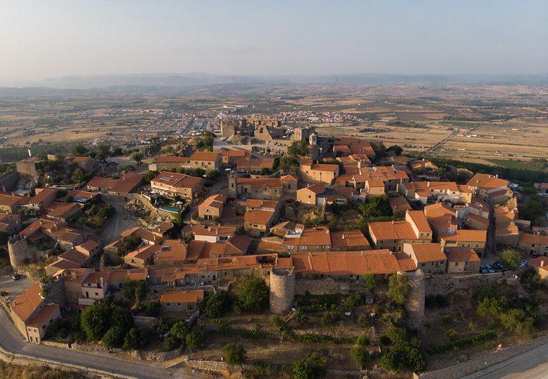
Caminha was a fishing community in the 13th century until King Afonso III chose to construct a modern castle and walled settlement on the bastide model, which was completed in 1260. During the period, the region was critical for military purposes due to its proximity to Galicia. Later Kings Dinis I and Ferdinand I strengthened the fortress. Finally, reclaimed land joined the original island to the mainland. Although the majority of the castle’s walls and towers have been demolished or rebuilt, the castle’s oval shape is still discernible in the design of several streets, and the keep tower remains intact and serves as an entrance to the historical centre. Another significant project of Dinis I was the establishment of the Camarido pinewood, which served to stabilise the sandbars at the mouth of the Minho.
The wetlands along the Coura are protected and provide excellent birding opportunities.
The Atlantic beaches in the vicinity are large and have decent sand, but are frequently windy during the day; the Moledo beach (4 kilometres south) is popular with surfers. Excursions by river and sea can be arranged with local fishermen.
South of the Coura, the Arga (823 m) little granitic range (“Serra”) offers excellent hiking, biking, and canyoning options. The little monastery of S. João de Arga (a popular spot for picnics, camping, and exploring peaks and streams; also the site of a religious festival) and the settlement of Castanheira are located on the forested northern slopes (scenic terraced fields and natural pools).
Every Wednesday, a weekly market is conducted. Local coppersmiths and lacemakers’ work may be spotted around town.
WHAT TO SEE AND DO:
Historical Heritage
Calvary – Vila Praia de Ancora

Calvário features fourteen crosses of remarkable simplicity, built on pedestals with an inscription relating to the respective step of the Way of the Cross, in religious, mannerist architecture.
Consisting of a wide stone staircase with twelve flights of eleven steps, delimited by a parapet in a granite masonry wall, plastered and whitewashed, with stonework capping, inscribing on each level a cross alluding to the stations of the Via Sacra, crowned by the three representative crosses of Monte do Calvário, already inside the churchyard.
The Calvário crosses feature a quadrangular step as a foundation, on which a parallelepipedic pedestal made of monolithic dice displays a descending cartouche engraved with the name of the appropriate stop of the Via Sacra.
Chapel of São Pedro Varais – Vile

It is situated in the parish of Vile, on the slopes of two hills in the Serra d’Arga foothills. This monument, which was constructed between the tenth and fourteenth centuries, is distinguished by its plain planimetric organisation and paucity of ornamental embellishments. It comprises a single nave and an unusual quadrangular chancel on its longitudinal layout. A solitary bell tower, typical of the Late Romanesque era, crowns the main façade.
The frescoed panels within the chapel originate from the first half of the 16th century and were restored in 1999.
Because it is the county’s oldest architectural structure, this chapel has been designated as a Property of Public Interest since 1950.
Our Lady of Lourdes Chapel / Monte do Calvário

Vila Praia de Âncora a religious and panoramic complex, dating from 1904, in Vila Praia de Âncora.
Casa dos Pitas – Caminha

Morgado Pitta’s institution in Aveiro, in the 19th century, XVII, gave birth to the union of some existing homes at the entrance of Rua da Corredoura, which gave rise, in the middle of the century, XVII, to the current Casa Pita.
This urban palace has two levels and a rectangular floor plan in the Manueline and Baroque revivalist styles.
Bevelled merlons cap the frontispiece, which is punctuated by half-cane gargoyles.
A stone containing weapons may be found on both sides of the window.
He got permission in 1648 to divert some of the water that supplied the fountain into the rear, and a tank was created in the garden in 1652.
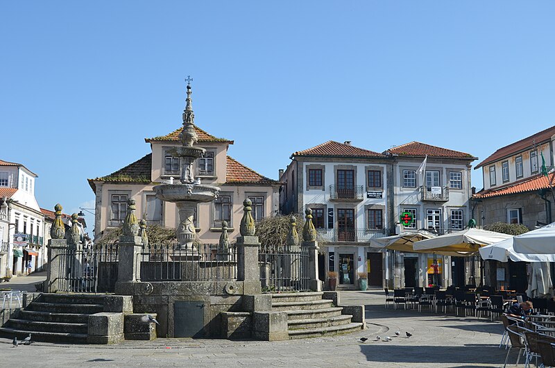
Caminha Fountain

João Lopes o Velho, an accomplished master, built it between 1551 and 1553. It’s a Renaissance fountain with a circular platform surrounded by iron railings. The circular tank features two overlapping basins and a spire-shaped top, as well as a galbated column and a pyramidal structure.
It was originally placed near the northern end of Terreiro, but during the liberal wars, the City Council ordered the removal of the pillory that stood in the plaza, and the fountain was relocated to its current location, which has undergone several renovations.
The Renaissance style is seen in the classicism of its lines and adornment, with the frowns standing out as one of the most notable fountains in northern Portugal and Galicia.
Anchor City

The stronghold, which dates from the centuries II and I BC, is one of the most important stations of Castro civilization, displaying a well-defined dwelling nucleus.
Situated on a hilly elevation on the left side of the Ancora river, it is encircled by three walls, various pieces of which are still visible, though not much protrudes from the ground.
It was built in proto-history for military and residential purposes, and it is now a historic-cultural landmark.
It is the remnants of a walled town with two lines of defensive walls and Roman traces.
The archaeological excavations at this site discovered valuable items that may be seen in the Caminha Municipal Museum.
Cruzeiro da Independência – Lanhelas

It is a monument commemorating the wars of independence. This monument, emblem and reference of the parish of Lanhelas, is juxtaposed to a windmill and attempts to commemorate the memorable occasion of April 23, 1644, when the residents of Lanhelas valiantly defended themselves from the Spanish invasion. Lanhelas Day is, in reality, held on this day, April 23.
In addition, the Cruzeiro da Independência is related with two additional noteworthy dates: 1140/1640 and 1940.
Dolmen da Barrosa – Vila Praia de Âncora

Vila Praia de Ncora’s funeral megalithic structure was named a national monument in 1910. It is regarded as one of the most important megalithic structures in the Iberian Peninsula, recording cultural characteristics of the late Neolithic period, i.e. the end of the third millennium and the beginning of the second millennium.
From an architectural standpoint, this monument, generally known as Lapa do Mouro, is constructed by a megalithic chamber (sepulchral area), consisting of 9 overlapping supports, supported by each other, 4 on each side, beginning with the somewhat fragmented chevet that implants vertically.
Ínsua Fort – Moledo

It has been designated a national monument since 1910 and is located on the islet of nsua in the parish of Moledo. When the monastery of Santa Maria da Ínsua was erected in the 14th century, it was occupied by a Franciscan community for the first time. The original stronghold, of which little survives, must also have been built during this time period. The fortification as we know it now dates from the 17th century, during King João IV’s reign.
The Franciscan monastery, which was enlarged in 1676, is integrated within the irregular star-shaped fort, which has five bastions and ravelin.
Lagarteira Fort – Vila Praia de Âncora

Forte da Lagarteira, also known as Forte de Âncora , is located in Portinho de Vila Praia de Âncora and has been designated as a Treasure of Public Interest since 1967. A nineteenth-century military fortification. XVII-XVIII, aimed at guarding the coast against the Spanish navy.
It is a star-shaped fortification with four side bastions and a three-sided battery on the riverfront façade.
This structure blends 17th-century elements with the retention of some of their mediaeval characteristics, such as the closed balcony.
Forte do Cão – Anchor

It is a fortress in the Gelfa area, between Praia da Gelfa and Mata do Gelfa. It is a defensive military structure constructed between 1699 and 1702 under D. Pedro II’s reign.
Forte do Cão was built with the purpose of guarding the Portuguese coast against piracy invasions. It is a stronghold in the shape of a star with four bastions, two of which face the sea. In 1967, Forte do Co is a Property of Public Interest.
Igreja da Misericórdia

In the town’s centre, adjacent to the Paços do Concelho, lies the 16th-century Igreja da Misericórdia, which is notable for its Renaissance gateway. The interior was redecorated in the 18th century with gilded sculptures in the Baroque and Rococo styles. The figure of St. Rita de Cássia stands out on one of the altars.
Igreja Matriz – Caminha

The authentic ex-libris of Vila de Caminha shows that it probably had two phases of construction, the first of which began in 1428 and the second in 1488, during the reign of D. João II. Its construction took about 60 years and was completed in the reign of King Manuel I.
Designed by the Biscaino architects Tomé de Tolosa and Francisco Fial, it is said to belong to the Manueline style because it was included in the set of churches built in the era of D. Manuel, but nothing else fits that style.
The Plateresque theme, of Spanish inspiration, is present in the decoration and in the geometric arrangement of the exterior elevations, as in all the churches of Biscainho artists.
The main door stands out for its decoration. It is made of an archivolt and is framed by an alfiz with plateresque designs—grotesques and arabesques—and protected by two giants that section the façade into three sections, finished in corocheus. Above the door is a frieze with fantastical animals in relief and a rose window.
Old Church – Vilarelho

So old that its foundation is unknown, the Old Church has been known since the Middle Ages. It was the spiritual seat of Caminha and Vilarelho until the construction of the Igreja Matriz, as the chapel destined for the religious services of Caminha, the chapel of Nossa Senhora da Piedade do Muro, was too small to receive the population. Christ Crucified was the image that crowned this church.
It is worth noting its old way of working, according to which the entrance to the church was completely discriminatory: the inhabitants of the village entered through the main door. Those from Vilarelho entered through the east door, and through the bridge (now boarded up), the fishermen and families who lived on Rua da Misericórdia entered.
If someone wanted to enter through a door other than the one intended for him, he had to ask permission from the person of greater honour and dignity present at the door.
Monastery of S. João D’Arga

The Monastery of S. João de Arga is located at the top of the Serra d’Arga (place of Arga de Baixo, Caminha) with ample visibility over the river Minho. Although the date of its foundation is unknown, its characteristics point to the end of the 13th century.
This construction of Romanesque architecture belongs to the group of small rural churches, with a single and short nave, a quadrangular main chapel, and very robust wall panels.
The chapel has undergone several renovations over the centuries. In 2015, the Sanctuary of S. João d’Arga was the subject of a conservation and enhancement project, which included conservation and improvement works in the church, in the hostels/barracks, in the outdoor spaces, in the public toilets, in the support building for the Sanctuary, and also the improvement and execution of some infrastructure.
Caminha’s 17th-century wall

After the Restoration of Independence in 1640, at a time when the Portuguese and Spanish were constantly facing each other and the danger of coastal piracy was imminent, the urban growth of Caminha posed major defensive and security problems, leading D. João IV to order the construction of the second line of walls that would surround the new housing districts.
City Hall – Caminha

In 1920, the Caminha City Council building underwent extensive renovations by the Vilarmourense José Porto. The main façade has several laced pinnacles, which copy two originals from the chapel of S. Sebastião.
Inside, the decoration of the Noble Room stands out, with its ceiling in masseira and phytomorphic motifs from the Mother Church, and the arch at the back of the 1st floor, reused from the chapel of S. Sebastião.
Vilar de Mouros Medieval Bridge

Since 1910, the Vilar de Mouros Bridge over the Coura River has been classified as a national monument.
Considered as one of the prototypes of Portuguese Gothic bridges, the Vilar de Mouros Bridge consists of three slightly broken arches, the medium one being larger, and a trestle deck. Although the exact date of its construction is unknown, its architectural features point to the end of the 14th century and the beginning of the 15th century.
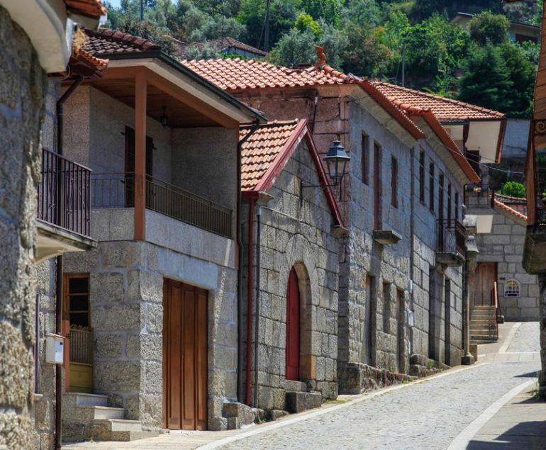
Rua Direita – Caminha

Caminha was originally planned according to the French urban planning model of the bastides. It had an oval wall that enclosed an orthogonal urban space, divided by three parallel streets on the major axis and three lanes on the minor axis, perfectly dividing the urban area into rectangular lots whose most important facades faced the main street, Rua do Meio, or Right Street.
If there is doubt about what else to admire, it is the sinuosity of the narrow slab streets; if the originality of the houses, revealing artistic facades and balconies with very interesting architectural elements.
Clock Tower – Caminha

The main tower of Caminha’s mediaeval fortifications provides entry to the village’s Medieval Historic Center. When facing south, the Portas de Viana were visible underneath, since this one leads to Viana do Castelo. It has a square design, two levels, and is now the Caminha castle’s only surviving turret. The clock that would give the tower its name was installed at the top of the tower in 1673. Since 1951, it has been designated a national monument.
It was requalified and upgraded in 2008, and the Museum Center of Caminha’s Historic Center was established, putting the Torre do Relógio building at the service of culture and tourism, with a focus on Caminha’s history and urban evolution from its origins to the present day.
BEACHES
Foz do Minho Beach
Foz do Minho beach is the northernmost maritime beach in Portugal and belongs to the mouth of the River Minho on the south bank, next to the border with Spain. It has a beach of about 1.2 km in length and a riverfront in the north. Nature lovers can enjoy the beauty of the Mata Nacional do Camarido that complements this fantastic setting. From here we can see the Forte da Ínsua which stands imposingly over the Ínsua de Santo Isidro, 400 metres from the coast.
Moledo beach
This beach is equipped with everything essential for enjoyment, and its therapeutic properties are well-known due to the high concentration of iodine. Its beauty deserves a visit at any time of year, especially when combined with outstanding surfing, bodyboarding, and windsurfing conditions.
Praia de Vila Praia de Ancora
The beach at Vila Praia de Âncora is ideal for making the most of the bathing season. Within the established quality requirements, the large beaches and sea, together with the terrain, ensure a memorable season for all visitors.
This beach is quite popular since it is equipped with all the required equipment for enjoyment, and its therapeutic properties, owing to the high concentration of iodine, are well-known.
Azenhas River Beach
This region remains a haven for holidaymakers on windy days and when the coastal beaches are fogged in. Praia Fluvial is located near Vilar de Mouros’s Roman Bridge, a location that is also equipped with a recreation area, picnic area, and outdoor areas for socialising.
Viewpoints (Miradouros)
Boavista Viewpoint – Vilarelho

It is next to the fort and features one of the most breathtaking vistas.
From this vantage point, you can overlook the town, the Minho River, and Foz.
It is a perfect location to serve as a source of inspiration for musicians, poets, and painters, among others.
Fraga Viewpoint – Vilarelho

This viewpoint, located in the parish of Vilarelho, is surrounded by the town’s walls.
From this vantage point, you can see the town of Caminha, the Clock Tower, the Minho River’s mouth, the Mata Nacional do Camarido, the imposing Forte da Ínsua, and Monte de Santa Tecla (Spain).
Senhora das Neves Viewpoint – Dem

At the Miradouro da Senhora das Neves, visitors can see Caminha, as well as the parishes of Vilar de Mouros, Argela, Venade, Vilarelho and Monte de Santo Antão in the distance.
The viewpoint of Monte de Santo Antão – Venade

From this viewpoint, enjoy a simply extraordinary landscape, which allows us to perceive the vastness of an unparalleled horizon.
On this hill is located the Chapel of Santo Antão, which was built at the beginning of the 18th century and rebuilt in 1775.
The viewpoint of Monte do Calvário – Vila Praia de Âncora

It is one of the most beautiful spots in the valley of the River Ancora to admire the landscape. Tourists have Âncora, Vila Praia de Âncora and Vile ‘at their feet’, with their monuments and wonderful landscape.
Contrasts abound here: the rich green of the valley contrasts sharply with the deep blue of the ocean… We are in a peaceful and somewhat magical location, sandwiched between mountains and sea.
Bell of the Moors Viewpoint – Moledo

It is one of the privileged places to admire the landscape over the valley of the River Ancora. Tourists have Âncora, Vila Praia de Âncora and Vile ‘at their feet’, with their monuments and wonderful landscape.
Here, the contrasts are great: the fertile green of the valley contrasts with the strong blue of the ocean… We are between the mountains and the sea, in a contemplative and almost mystical place.
Hiking Trials
Cabeço do Noon Trail

With a cultural scope and a short route, this route covers 8 km with an easy degree of difficulty.
Departing from the Capela de Santo Antão, hikers pass through several forest paths, cross the Pombas stream, to visit the Moinho das Pombas from below. They also pass by Moinho Velho and Moinho Novo. Arriving at Cabeço do Meio-Dia, hikers are at a latitude of 550 metres and head towards Moinho de Baixo, via the bridge and mills of Gândara. This route ends at Pontão do Lobo, which is of incalculable value to the architectural and ethnographic heritage of Serra d’Arga.
Starting point
Chapel of Santo Antão -Arga de Cima
course duration
3 hours
Maximum Quota Achieved
550 metres (Noon Head)
Pedra Alçada Trail

This route leads to the municipality’s highest point—Pedra Alçada, at 742 metres above sea level—from where a wonderful panoramic view of the sea and the mouths of the Minho and Coura rivers may be enjoyed.
Along with the breathtaking scenery, the route highlights many tree, shrub, and plant species, the Monastery of São João d’Arga, waterfalls, and natural sceneries produced by the S. João stream, as well as the characteristic settlement of S. Joo d’Arga.
Starting point
The Church of Arga de S. João Square
duration of the course
4–5 hours.
Obtained a Maximum Quota
742 m (Heaved Stone)
Trail Between the Sea and the Mountain
This trail, which has a scenic and ecological focus and a short route, is 19.3 kilometres long and moderately difficult.
It begins next to the Camarido Camping Park and continues through the walls to Monte de Santo Antão, in Alto da Espiga, providing views of the Minho and Coura rivers estuaries.
Continue to the Romanesque chapel of St. Pedro de Varais for a spectacular view of the Ancora river valley and the Atlantic coast.
You will next come to Cobertorinho’s geodesic landmark and, farther on, a Cross that culminates in the Sino dos Mouros rock.
You arrive at Moledo beach after crossing the EN 13.
One returns to the starting point after crossing the Mata Nacional do Camarido.
Vilarelho is the starting point of the route.
Commencement point
Comrade car park
Course duration: 5 hours and 30 minutes
Attained 410 metres (Alto da Espiga)