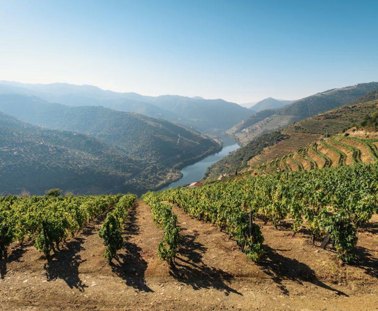
Seven Wonders of Portugal is a list of cultural wonders in Portugal.
Castle of Guimarães 10th century
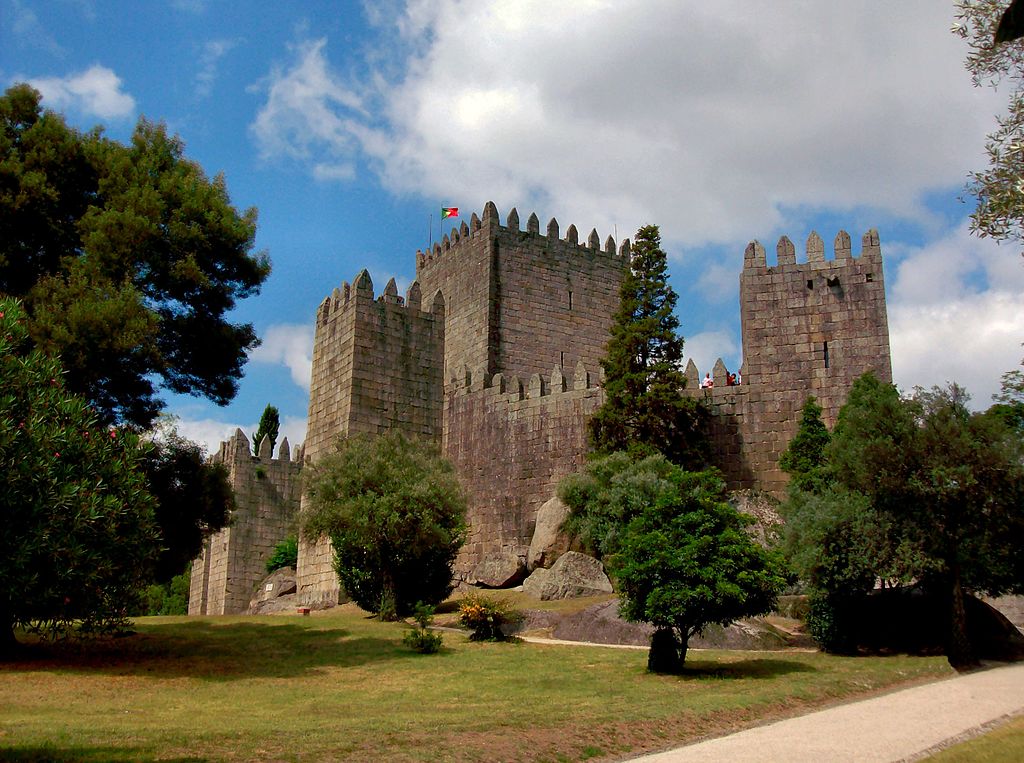
Guimarães Castle (Portuguese: Castelo de Guimarães) is the main medieval castle in the municipality of Guimarães, in the northern region of Portugal. It was built in the tenth century on the orders of Mumadona Dias to protect the monastery from raids by Moors and Norsemen.
The castle is a military structure that originated in the late Romanesque period and was developed during the early Gothic period in Portugal. It is surrounded by walls in the shape of a pentagram, with eight rectangular towers, a military square, and a central keep. Built on the foundations of a Roman structure described in the works of Alfredo Guimares, it was later developed on the French model, in the form of a shield with a reduced central courtyard and limited access. Due to its reconstruction at the end of the 13th century, which created the keep and the houses, it retains some Gothic elements (possibly on top of pre-existing structures).
Guimarães is emblematic of the medieval Portuguese castle and is associated with the origins of the Portuguese nation.
The castle is located within the northern limits of Guimarães, isolated on a small granite hill, surrounded by a small wooded park with several pedestrian paths. Next to the southern tower is a bronze medallion by D. Afonso Henriques, on top of a large rock. Nearby, on the hillside, are the Romanesque church of São Miguel do Castelo and the palace of the Dukes of Braganza, as well as some sections of the wall that surrounded the city, which was originally integrated into the castle.
Guimarães, Braga GPS 41.4479°N 8.2906°W
Castle of Óbidos 1195

Óbidos Castle is a well-preserved medieval castle in the parish of Santa Maria, São Pedro e Sobral da Lagoa, in the parish of Óbidos, in the Portuguese district of Leiria.
Óbidos was founded on the existence of a fortified settlement, most likely on the hill overlooking the Luso-Roman castle and Roman oppidum (then civitas), known as the mysterious Eburobrittium, which Pliny the Elder once mentioned as being located between Collipo (modern Golpilheira, near Leiria) and Olisipo (Lisbon). Archaeological research has revealed the presence of a forum, baths, and other Roman structures in the vicinity of the village. The area was later inhabited by the Lusitanians (from the 4th century B.C.) and the Romans in the 1st century, but was later invaded by the Visigoths in the 5th and 6th centuries and by the Moors in the 8th century, who were responsible for fortifying the town.
The trapezoidal castle faces south-east and rises 79 metres above sea level, in the extreme north-west corner of the walled enclosure. It is reinforced in the north by three semicircular and rectangular corbels; in the east and west by rectangular corbels known as the D. Dinis and D. Fernando towers; in the south by two semicircular corbels, one with machicolations; and in the north and west by a barbican. A graceful rectangular arch, known as the Albarrã Tower, runs along the wall dividing the two courtyards. The castle’s architecture, influenced by Romanesque, Gothic, Baroque, and Manueline styles, is divided into two sections: the Castelejo (now known as the Inn or Pousada de Obidos) and the interior.
The courtyard has an irregular triangle shape and is surrounded by square merlons with sills and crenellations. The perimeter of the walls, reinforced by square and cylindrical crenellated towers, is 1,565 metres long and is completely enclosed by a battlement guarded by a crenellated parapet. To the west, a line of walls, reinforced by huge rectangular towers, runs along the rocky cliffs. The Cerca Gate, the Talhada Gate and the Jogo da Bola watchtower interrupt this line of walls, which ends in the southwest with the Facho tower. From here, the walls are irregularly shaped to follow the relief of the land to the north-east, bending towards the north and east and supported by semicircular corbels and the minarets of the castle. The walls reach a height of 13 metres (43 feet) in places.
A 3 km aqueduct was built by Queen Catherine of Austria, wife of King John III (1521-1557), to bring water from the Usseira highlands to bidos to fill the city’s fountains.
Óbidos, Leiria GPS 39°21.819′N 9°09.428′W
Batalha Monastery, 1385

Batalha Monastery (Portuguese: Mosteiro da Batalha) is a Dominican convent located in the town of Batalha, district of Leiria, Portugal’s Centro Region. Originally and officially known as the Monastery of Saint Mary of the Victory (Portuguese: Mosteiro de Santa Maria da Vitória), it was built in remembrance of the 1385 Battle of Aljubarrota and was intended to serve as the burial church for the Portuguese royalty of the 15th-century Aviz dynasty. It is one of the best and most unique instances of Late Flamboyant Gothic architecture in Portugal, incorporating Manueline elements.
The monastery was built to thank the Virgin Mary for the Portuguese victory over the Castilians in the battle of Aljubarrota in 1385, fulfilling a promise of King John I of Portugal.
The convent is a separate entity from the town.
The western façade, which faces the wide square with its equestrian statue of general Nuno Álvares Pereira, is divided into three sections by buttresses and massive pilasters: the Founder’s Chapel (Capelo do Fundador), an aisle’s sidewall, and the projecting gateway. The Unfinished Chapels (Capelas Imperfeitas) are a freestanding octagonal structure erected to the complex on the right side of this façade.
The Chapterhouse is located on the east side, adjacent to the church choir (Sala do Capitulo). King João I Cloister abuts the church and this chapterhouse. The construction continues into King Afonso V’s cloister (Claustro de D. Afonso V). The Tomb of the Unknown Soldier from the First World War is located on the complex’s northern flank.
The archivolt contains a profusion of 78 statues of Old Testament kings, angels, prophets, and saints, each with its own baldachin. On both sides, splays depict (poor copies of) apostles, one of them is standing on a chained devil. Christ is enthroned in the tympanum, seated beneath a baldachin and flanked by the four Evangelists, each with his particular attribute.
Batalha, Portugal GPS 39°39′33″N 8°49′34″W |
Alcobaça Monastery, 1153

The Alcobaça Monastery (Portuguese: Mosteiro de Alcobaça, Mosteiro de Santa Maria de Alcobaça) is a Catholic monastic complex located in the town of Alcobaça, in central Portugal, some 120 km north of Lisbon. The monastery was established in 1153 by the first Portuguese king, Afonso Henriques, and would develop a close association with the Portuguese monarchy throughout its seven-century-long history.
The church and monastery were the first Gothic buildings in Portugal, and, together with the roughly older Augustinian Monastery of Santa Cruz in Coimbra, it was one of the most important mediaeval monasteries in Portugal. Due to its artistic, cultural and historical relevance, it was included in UNESCO’s World Heritage Site list in 1989.
The Alcobaça Monastery was one of the first structures in Portugal affiliated with the Cistercian Order. It was founded in 1153 as a gift to Bernard of Clairvaux by the first Portuguese king, Afonso I or Afonso Henriques (1112–1185), following the king’s capture of the Moorish city of Santarém in March 1147. The monastery was founded as part of King Afonso I to strengthen his rule and promote colonization of previously won regions from the Moors during the “Reconquista Cristã” or Reconquista.
The Alcobaça Monastery was erected in an early Gothic style, marking the entrance of this style in Portugal. The church and other major structures were built between 1178 and the end of the 13th century. In 1252, the church was dedicated. The original monastic buildings were erected along lean architectural lines, with no adornment other than some capital sculpture and a figure of the Virgin Mary, in accordance with the rules of the Cistercian Order.
| Alcobaça, Portugal GPS 39°32′54″N 8°58′48″W |
Jerónimos Monastery, 1502

The Jerónimos Monastery, also known as the Hieronymites Monastery (Portuguese: Mosteiro dos Jerónimos), is a former monastery of the Order of Saint Jerome in the parish of Belém, Lisbon Municipality, Portugal.
In Lisbon, the monastery is one of the most visible specimens of the Portuguese Late Gothic Manueline style of construction. It was designated a UNESCO World Heritage Site in 1983, together with the adjacent Tower of Belém.
The Jerónimos Monastery replaced a church dedicated to Santa Maria de Belém in the same location, where monks of the military-religious Order of Christ assisted mariners in route. The port of Praia do Restelo was a desirable location for mariners, offering secure mooring and protection from the winds, which were desired by ships entering the Tagus mouth. The current edifice was built in 1495 at the Montemor o Velho courts on the instructions of Manuel I (1469–1521) as a final resting place for members of the House of Aviz, in accordance with his idea that an Iberian dynastic monarchy would govern after his death. In 1496, King Manuel requested permission from the Holy See to build a monastery on the site. The Hermitage of Restelo (Ermida do Restelo), as the church was known, was already in disrepair when Vasco da Gama and his crew prayed there the night before embarking on their trip to the Orient in 1497.
Santa Maria de Belém, Lisbon GPS 38.6975°N 9.206667°W
Pena Palace, 1854

The Pena Palace (Portuguese: Palácio da Pena) is a Romanticist castle in São Pedro de Penaferrim, in the municipality of Sintra, on the Portuguese Riviera. The castle stands on the top of a hill in the Sintra Mountains above the town of Sintra, and on a clear day, it can be easily seen from Lisbon and much of its metropolitan area. It is a national monument and constitutes one of the major expressions of 19th-century Romanticism in the world. The palace is a UNESCO World Heritage Site and one of the Seven Wonders of Portugal. It is also used for state occasions by the President of the Portuguese Republic and other government officials.
The Pena Palace has a profusion of styles much in accordance with the exotic taste of Romanticism. The intentional mixture of eclectic styles includes the Neo-Gothic, Neo-Manueline, Neo-Islamic and Neo-Renaissance. Much of this has been evident since major renovations in the 1840s. References to other prominent Portuguese buildings, such as the Belém Tower, are also present.
Almost the entire palace stands on a rock in the Sintra Mountains. Structurally, it can be divided into four sections:
- the foundations and its enveloping walls, with two gateways (one of which is protected by a drawbridge)
- the restored structure of the old convent, and the clock tower
- the Arches Yard in front of the chapel, with its wall of Moorish arches
- the palatial zone and its cylindric bastion, with interiors decorated in the cathédrale style.
Sintra, Lisbon GPS 38.787778°N 9.390556°W
Belém Tower, 1521
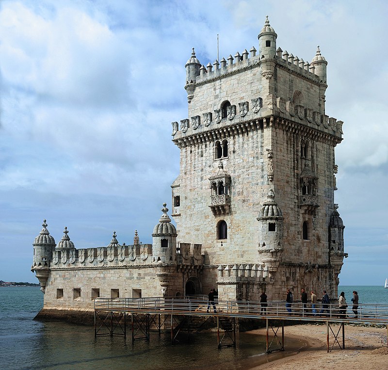
Belém Tower (Portuguese: Torre de Belém, officially the Tower of Saint Vincent (Portuguese: Torre de S. Vicente)) is a 16th-century fortress in Lisbon that functioned as a point of embarkation and disembarkation for Portuguese explorers as well as a ceremonial gateway to the city. It was constructed during the Portuguese Renaissance’s height and is a noteworthy example of the Portuguese Manueline style, while it also combines elements of other architectural styles. The structure is made of lioz limestone and consists of a bastion and a four-story, 30-metre (98.4 ft) tower.
Since 1983, the tower, along with the Jerónimos Monastery, has been a UNESCO World Heritage Site. Due to its iconic importance, it is frequently shown as a symbol of Europe’s Age of Discovery and as a metonym for Portugal or Lisbon. It has been mistakenly asserted that the tower was built in the middle of the Tagus and later relocated to the coast during the 1755 Lisbon earthquake. Indeed, the tower was constructed on a small island in the Tagus river near the Portuguese capital’s shore.
The Belém Tower is located on the northern bank of the Tagus River in the municipality of Lisbon, in the civil parish of Santa Maria de Belém. It is accessible through a tiny bridge at the western end of the Avenida de Braslia. To the east is the Jeronimos Monastery, to the west is the Forte do Bom Sucesso, and to the north is the tower Governor’s residence, the original Governor’s residence for the Forte do Bom Sucesso, and the Chapel of São Jerónimo.
The tower lies isolated along the riverbank, between Bom Sucesso and Pedrouços, on a basaltic outcrop of rocks from the Lisboa-Mafra geomorphological volcanic complex. Although several guides state that the tower was built in the middle of the Tagus and relocated to the shore following the 1755 earthquake, this is not the case. According to the Portuguese Ministry of Culture and the Institute of Architectural Heritage, the tower was built on a tiny island along the Tagus’s bank, opposite Restelo’s beach. As expansion stretched the shoreline, more and more of the northern bank sank into the Tagus, gradually integrating the tower into the riverbank.
The Belém Tower was constructed using a beige-white limestone found in the Lisbon area and environs known as Lioz. The structure is broken into two sections: the bastion and the four-story tower on the bastion’s north side.
The sixteenth-century tower is regarded as a masterpiece of the Portuguese Late Gothic Manueline architecture. This is particularly evident in its ornate rib vaulting, Order of Christ crosses, armillary spheres, and twisted rope, all of which are characteristic of the nautically inspired organic Manueline style.
Santa Maria de Belém, Lisbon GPS 38.691389°N 9.215833°W