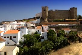
The Bragança Castle, or Castelo de Bragança in Portuguese, is a well-preserved mediaeval castle located in the heart of Bragança, Portugal. It is in the Bragança neighbourhood.
The castle is in excellent condition. Its stormy history stretches from possession during the Moorish period through destruction and reconstruction during the Christian reconquest of the Iberian Peninsula. It serves as a memorial to Portugal’s past.
The castle of Bragança was classified as a national monument by decree on June 23, 1910. The General Directorate of National Buildings and Monuments began extensive restoration and reconstruction of the walls. Since 1936, a historic military museum has been housed on the premises of the keep. Castle of Bragança, Book of Fortresses 1509-1510 Early history
Archaeological evidence suggests that early human settlers in the area built a fort of some sort. Later, during their occupation of the Iberian Peninsula, the Romans expanded and improved the stronghold. The fortification, however, was destroyed when the Muslims arrived. They reconstructed the castle.
A viewpoint of the ancient castle of Bragança
Paleolithic-era human settlement in this area can be determined by archaeological evidence. Neolithic settlements grew and became more productive as people focused on farming and taming animals. At the same time, a primitive religion began to form. These prehistoric societies left behind a wide variety of artifacts, including ceramics, forged-from-rock jewelry, weights, arrowheads, and farming tools. Many of these objects were found in grave mounds, like the tumulus of Donai (mostly destroyed). There are various indications of megalithic structures all across the area. Terra Fria is thought to have had bigger prehistoric villages, most likely in the second half of the Bronze Age (1000–700 BC). During this time period, the Castro culture of fortified urban constructions resulted in the construction of walled communities in elevated areas with panoramic views for defence. Subsistence farming was the main source of income for many communities.
Roman colonisation, which happened late in the Roman era, resulted in the development of private property and a migration away from the woodlands, as well as organisational changes brought about by administrative, material, and cultural evolution. In the Castros of Sacóias and Avelãs, remnants of the Luso-Roman castro societies are discernible. Modern archaeologists have unearthed funerary remains, money, and artefacts at these sites. The Castro of Avelãs (about three kilometres from Bragança) was an important centre on the military road to Astorga, despite the presence of several Roman remains (in Alfaião, Aveleda, Carrazedo, the Castro de Avels, Donai, França, Gostei, Meixedo, Pinela, Quintela Lampaças, etc.). The region was dominated by two distinct ethnic groups: the Zoelae, whose capital was Castro de Avelãs, and a Lusitanian civitas governed by the Baniense in the southern portion of the territory. A Latin map, Atlas de Gotha by Justus Perthes, noted three settlements in this region: Aquae Flaviae (Chaves), Veniatia (Vinhais), and Zoelae (its capital in Zoelas, today Castro de Avelãs), but made no mention of a place with a name similar to Bragança. During Roman colonisation, it was part of Gallaecia and administratively dependent on Astorga, which controlled the gold, iron, and silver trade and was located on the Atlantic axis of a Roman roadway from the Meseta. In the Vergancia-related acts of Council Lugo (569 AD), a village with a name similar to Bragança is mentioned. In 666 B.C., Visigoth King Wamba made a similar claim about Bregancia, which was said to be the birthplace of two Christian martyrs (John and Paul).
Early history
Archaeological evidence suggests that early human settlers in the area built a fort of some sort. Later, during their occupation of the Iberian Peninsula, the Romans expanded and improved the stronghold. The fortification, however, was destroyed when the Muslims arrived. They reconstructed the castle.
A viewpoint of the ancient castle of Bragança
Paleolithic-era human settlement in this area can be determined by archaeological evidence. Neolithic settlements grew and became more productive as people focused on farming and taming animals. At the same time, a primitive religion began to form. These prehistoric societies left behind a wide variety of artifacts, including ceramics, forged-from-rock jewelry, weights, arrowheads, and farming tools. Many of these objects were found in grave mounds, like the tumulus of Donai (mostly destroyed). There are various indications of megalithic structures all across the area. Terra Fria is thought to have had bigger prehistoric villages, most likely in the second half of the Bronze Age (1000–700 BC). During this time period, the Castro culture of fortified urban constructions resulted in the construction of walled communities in elevated areas with panoramic views for defence. Subsistence farming was the main source of income for many communities.
Roman colonisation, which happened late in the Roman era, resulted in the development of private property and a migration away from the woodlands, as well as organisational changes brought about by administrative, material, and cultural evolution. In the Castros of Sacóias and Avelãs, remnants of the Luso-Roman castro societies are discernible. Modern archaeologists have unearthed funerary remains, money, and artefacts at these sites. The Castro of Avelãs (about three kilometres from Bragança) was an important centre on the military road to Astorga, despite the presence of several Roman remains (in Alfaião, Aveleda, Carrazedo, the Castro de Avels, Donai, França, Gostei, Meixedo, Pinela, Quintela Lampaças, etc.). The region was dominated by two distinct ethnic groups: the Zoelae, whose capital was Castro de Avelãs, and a Lusitanian civitas governed by the Baniense in the southern portion of the territory. A Latin map, Atlas de Gotha by Justus Perthes, noted three settlements in this region: Aquae Flaviae (Chaves), Veniatia (Vinhais), and Zoelae (its capital in Zoelas, today Castro de Avelãs), but made no mention of a place with a name similar to Bragança. During Roman colonisation, it was part of Gallaecia and administratively dependent on Astorga, which controlled the gold, iron, and silver trade and was located on the Atlantic axis of a Roman roadway from the Meseta. In the Vergancia-related acts of Council Lugo (569 AD), a village with a name similar to Bragança is mentioned. In 666 B.C., Visigoth King Wamba made a similar claim about Bregancia, which was said to be the birthplace of two Christian martyrs (John and Paul).
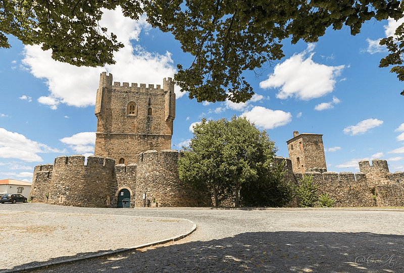
The castle stands at a height of 800 metres above sea level. The site floor plan indicates an ovoid plant with a battlement and a perimeter of 660 meters. The walls are reinforced by fifteen turrets. Walls two metres thick surround the historic core of the city, enclosing three hectares of land. The keep houses the Church of Santa Maria and the mediaeval pillory. The main San Antonion port is a round arch within two turrets and is defended by a barbican.
The walls are constructed using masonry shale rock that is abundant in the region. It can be found in the corners and every opening. Originally, a drawbridge was intended for the door, but it has decayed since and been replaced by a heavy door. On the southern side of the castle, there is a gun stone with the coat of arms of Avis House. The top is crowned by battlements with cruzetadas battlements, balconies with boulders, and four cylindrical watchtowers at the corners, dominating the eastern side and the south side, with two Maineladas Gothic windows. A fence, reinforced by seven turrets (three east, three west, and three south) of a circular plan, tops the exterior of the tower.
From its walls, one can see the mountains of Montesinho to the north, Sanabria to the west, and the Castle of Rebordões to the east.
 Era of the middle ages Bragança Castle, 1509–1510, Book of Fortresses The fortress was referenced in a document dated July 7, 1128, claiming that it was brought under the administration of King Afonso I of Portugal (1112-1185). The settlement was moved to its current location for defensive reasons, close to the hill of Benquerença on the Fervença River’s bank, using recycled materials in the building of new residences and a castle for the populace’s defense. The town received its Foral charter from King Sancho I (1185–1211). The sovereign endowed the village with funds to construct a wall and castle in 1187. During this time, the conflict between Sancho I and León resulted in violence and saw Leonese forces take over the village. During the reign of King Denis (1279–1325), the village built a walled perimeter in 1293, indicating the village’s prosperity. His illegitimate brother’s assets were seized by his successor, King Afonso IV (1325–1357). In order to protect its interests, Afonso Sanches launched a rebellion, invading Braganza and causing extensive damage. The widow of King Denis restored peace. Conflicts between this sovereign and King Alfonso IX of León resulted in the region being invaded by forces from León (1199), prompting the Portuguese sovereign to respond.
from the twentieth century to the present
On June 23, 1910, the castle of Bragança was designated a national monument by decree. The walls were extensively restored and rebuilt by the General Directorate of National Buildings and Monuments. The keep’s grounds have served as the home of a historical military museum since 1936.
The castle stands at a height of 800 metres above sea level. The site floor plan indicates an ovoid plant with a battlement and a perimeter of 660 meters. The walls are reinforced by fifteen turrets. Walls two metres thick surround the historic core of the city, enclosing three hectares of land. The keep houses the Church of Santa Maria and the mediaeval pillory. The main San Antonion port is a round arch within two turrets and is defended by a barbican.
The walls are constructed using masonry shale rock that is abundant in the region. It can be found in the corners and every opening. Originally, a drawbridge was intended for the door, but it has decayed since and been replaced by a heavy door. On the southern side of the castle, there is a gun stone with the coat of arms of Avis House. The top is crowned by battlements with cruzetadas battlements, balconies with boulders, and four cylindrical watchtowers at the corners, dominating the eastern side and the south side, with two Maineladas Gothic windows. A fence, reinforced by seven turrets (three east, three west, and three south) of a circular plan, tops the exterior of the tower.
From its walls, one can see the mountains of Montesinho to the north, Sanabria to the west, and the Castle of Rebordões to the east.